Article title
Some people are weatherwise, but most are otherwise.
Benjamin Franklin
Weather maps
Materials: weather map.
Activity procedure Use the data to interpret your map.
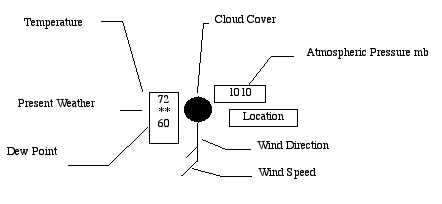
Atmospheric pressure. millibars (mb). Air pressure at sea level averages 1013 mb (14.7 lb./in2 or 1.04 kg/cm2 or 760 mm Hg or 29.92 in. Hg)
Wind speed. Each line represents 10 knots (kt) 1 kt = 1.5 mph = 1.8 kph) Short lines represent 5 knots. Add the lines to get the total air speed.
Wind direction. The circle represents the arrow head. The arrow points the direction the wind is blowing, but wind direction is referenced from the direction the wind is blowing. An arrow may point to the east and the wind is from the west.
Temperature is measured in degrees F every hour.
Dew point is the temperature in degrees F the air would have to be cooled to for the air to become saturated and for water vapor in the air to condense.
Cloud cover is the amount of the circle that is blackened. White = clear, All black is 100% covered, An X means the sky is obscured.
Present weather is illustrated with symbols
l One dot is intermittent rain
l l Two dots is continuous rain (light)
A triangle is hail
A triangle with a dot in it is sleet
* is intermittent snow
** Continuous snow (light)
, is intermittent drizzle
,, is continuous drizzle
Four crocked lines with an arrow is thunderstorm
= is fog
A triangle with a dot above the top edge is slight rain showers
A triangle with a line in the middle and a dot above the top edge is moderate or heavy rain showers